Contents
Balkh
|
Dashly
Location of the Dashly Sites
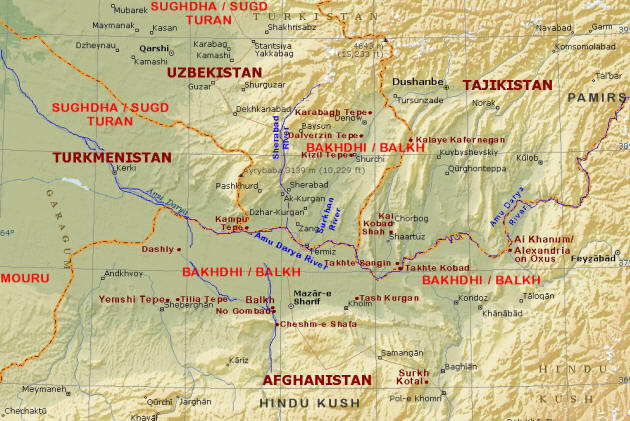
The Dashly archaeological sites are located south of the Amu Darya River in Northern Afghanistan's Jozjan Province about 38 km north-east of Aqcha and 65 km northwest of Balkh, just to the east of the Aqcha-Kilift road. In ancient times, the cities and settlements of Dashly would have come within the orbit of the Ancient Aryan nation of Bakhdhi (later Balkh) otherwise known to the West as Bactria. The layout of the sites is
comparable to those found north of the Amu Darya River as well as in the Murgab delta state of Mouru (Merv/Margiana).
Dashly consists of forty-one archaeological sites spread over 100 sq. km., and whose occupation have been dated from the Bronze Age (c. 2500-1700 BCE) to the Kushan period (c. 3rd cent. CE). The two principal Bronze Age sites are Dashly 1 and the older Dashly 3. Some of the other sites of the same period are Dashly 2, 4, 5, 10, 11, and 12, each approximately 200 x 150 m. in size. The artefacts uncovered include elegantly shaped unpainted fast-wheel pottery. Shards of ceramic, flints and bronze artefacts are reported to have been carelessly scattered around the sites. Soviet archaeologist Viktor Sarianidi excavated the ruins in the 1970s. Some of Sarianidi's conclusion as suspect given his fantastic, unsupported or unverified conclusions regarding his work at the Gonur site in neighbouring Turkmenistan.
Dashly 1
The primary site, Dashly 1 is three km southwest of Dashly 3, four km north of Dashly South, and 10 km west of Dashly East. It consists of the ruins of a100 x 90 m. mud-brick square citadel with 2 m. high walls overlooking a settlement covering an area some 150 x 120 m in size. It occupation is dated to the late 2nd millennium BCE and after the destruction of the citadel, its ruins appear to have been used as a Bronze Age cemetery. Finds have included bronze weapons and jewellery.
Dashly 3
Dashly 3 site consists of two complexes and its occupation is dated to the late Bronze Age, (2300-1700 BCE) and the Iron Age (1700-800 BCE). Pottery, stone vessels and
jewellery found at the site are comparable to those found in Turkmenistan and north-eastern Iran.
The older of the two Dashly 3 complexes, sometimes identified as a palace, is a fortified rectangular 88 x 84 m compound. It is the shape of this complex's outer defences that have attracted attention and comment. The square building had massive double outer walls and in the middle of each wall was a protruding salient composed of a T-shaped corridor flanked by two L-shaped corridors. Within the walls were several house-like buildings and a relatively large storehouse with long, parallel corridors ostensibly used for housing jars while with grain or other supplies. This complex was later replaced by a fortress, which appears to have been rebuilt several times.
The "younger" second Dashly 3 complex, incorrectly labelled a temple complex, consists of an inner citadel-like structure surrounded by closely packed residence-like structures. The citadel (a fortified palace) consists of what appears to be a relatively modest residence and a storehouse surrounded by a circular double wall buttressed by square towers. The circular defensive walls are approximately 45 m in diameter. Surrounding the citadel's walls are the closely packed house-like structures themselves surrounded and protected by two rings of was and finally a rectangular outer wall measuring about 130 x 150 m.
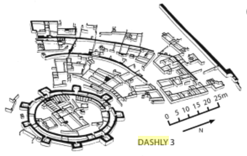 |
| Younger Dashly 3 aerial view. |
 |
| Younger Dashly 3 section plan. |
|
Surrounding tombs and graves have been looted and the artefacts are said to have been sold in the bazaar at Kabul (P. Amiet in
Bactriane Proto-Historique, Syria 54, 1977, pp. 89-121). These artefacts show common elements with artefacts from other settlements in Central Asia and the perimeter of the Indus Valley linking the settlements and regions culturally in the 3rd millennium BCE. For instance the Dashly artefacts have common elements with those found at Sapalli Tepe located north of the Amu Darya; from Togolok to the west of Dashly in the Murgab delta now in Turkmenistan, and from site south of the Hindu Kush near Quetta and Sibri. Some authors believe the artefacts also show affinities with those from Elam (in the south-west of the Iranian plateau) dated to the beginning of the 2nd millennium BCE.
Dashly 3 Plan Drawing, Yantra Motif and Textile Designs
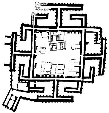 |
| Dashly 3 ground-plan drawing |
|
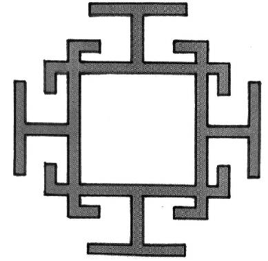 |
| Dashly 3 plan schematized |
|
 |
| 15th century Eastern Anatolia carpet design (Vakiflar Museum, Istanbul) |
|
|
 |
| Another carpet design |
|
 |
| A carpet design |
|
 |
| The Mahakali Yantra motif |
|
|
 |
Kalachakra thangka from Sera Monastery.
The image is that of the building/palace at Mount Meru
and the same as that found in the Mahakali Yantra motif.
(Also see CCSU 1 and CCSU 2). Image credit:
Wikipedia. |
While we do not wish to indulge in speculation or the development of speculative constructs, there has been some discussion in the literature about the shape of the older Dashly 3 building, a shape that is fairly unique and a similar shape found in Yantra and carpet designs from the region. The Yantra is a geometrical motif sometimes used as a meditation aid. In Sanskrit, Yantra means "instrument" or "machine". Mandala loosely means circle. Our interest in the Yantra is the similarity of some of its representations such as the Mahakali Yantra found in tantric mandalas with the ground-plan drawing of the older Dashly 3 building.
The tantric mandala embodies the Yantra as a design of the sanctum at Mr. Meru in Shambhala. Yantra, Mantra and Tantra (the text) are similar sounding words and the Yantra has spiritual, astrological and magical associations in the tantric traditions of some Indian religions. According to the L. B. Lama Thanka Arts Gallery, the "Kalachakra Mandala thangka is surrounded by a ring of fire. Fire in Tantrism means knowledge. The Kalachakra mandala thangka has at its center Mount Meru (in Shambala) with the four corners of the world around it." The four protrusions at the side are four entrances / doors / gates.
Mount Meru (in Aryana) of Buddhist and Hindu beliefs is likely the same as the high peak of the Hara mountains of Airyana Vaeja (also see our page on the Location of the Aryan Homeland).
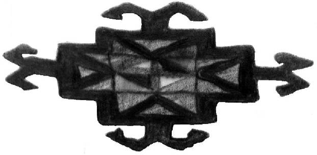
Variations of the schematic design of the Dashly 3 plan can also be seen in carpets. The 15th century carpet design shown in the top right is also found in Caucasian, Turkoman and Uzbek carpets. Textile designs as well as paintings could have been a way to record and convey architectural shapes.
The similarity in the design examples we have shown here can be purely coincidentally or somehow linked.
In any event, there is no suggestion here that the building/citadel at Dashly 3 is in any way connected,
mythically or otherwise, to the palace of the gods atop Mount Meru. For one thing, the land of Mount Meru was mountainous and not a flat plain.
Dashly East
Dashly East is the eastern-most of the Dashly sites and is located 4 km north of Dilbarjin. It is a collection of eight low mounds stretching northwest to southeast for about 3 km. Each mound is approximately 200 x 150 meters in size and contain ruins of buildings once occupied in the late Bronze Age, i.e. in 2nd millennium BCE.
Dashly South
Dashly South consists of five late Bronze Age (2nd millennium BCE) and Achaemenid era (6th-4th century BCE) mounds called Dashli 30-33 and Aq Chapur 12.
Aq Chapur
Part of the Dashly complex, Aq Chapur consists of two sites, 1 & 2. Aq Chapur 1 is 5 km southeast of Aq Chapar village, 2.45 km northeast of Aqcha and 9 kilometres east of the road to Kilift. Aq Chapur 2 is 1.5 km northwest of Aq Chapar village, and 3 km south of Dashly 3.
The occupation of Aq Chapur is dated to the Kushan period, that is, between the 1st and 3rd centuries CE, while that of Aq Chapur 2 is dated to a much earlier time - the Iron Age of the early 1st millennium BCE.
Aq Chapur 1 consists of a fairly large, roundish polyhedral building about 130 m. in diameter, surrounded by a double ring of outer fortification walls. A gallery separates the walls and the building. The outer fortification wall is pierced by embrasures - slanted, tapered openings wider on the outside and designed so that a defender can fire through them on attackers. The walls are also reinforced by buttress-like salients measuring four meters square.
Aq Chapur 2 is a larger monumental building some 170 m. in diameter with a roundish polyhedral shape. Its layout is similar to that of Aq Chapar 1, being surrounded by a one-metre thick wall reinforced by 25 to 27 towers, each 4 m square.
External page of interest:
» Bactrian Documents from Ancient Afghanistan
» Top
|
