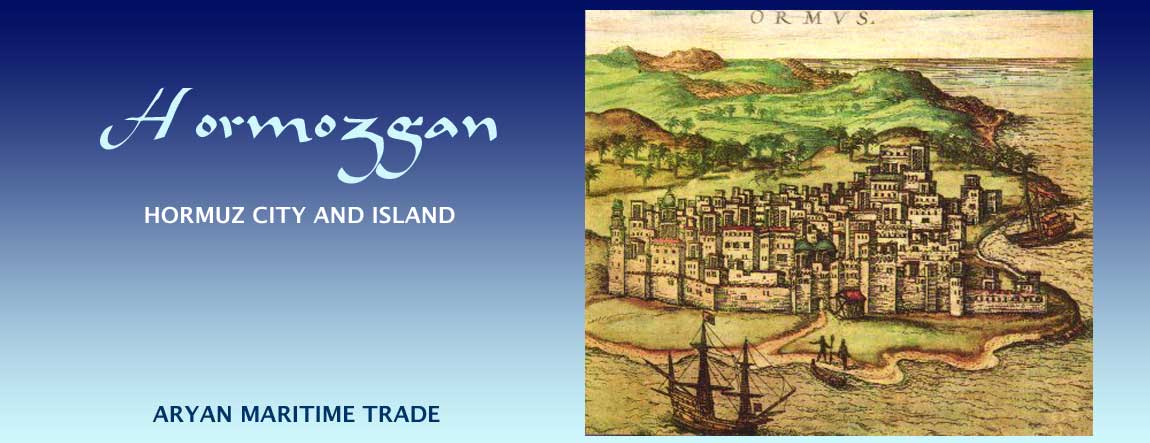
Banner image: 1577 CE Etching of Ormus in Civitates Orbis Terrarum by Frans Hogenberg and Georg Baum in several volumes 1572 - 1618, at the Biblioteca Nacional de Portugal

ContentsPeople & PlacesPage 1Page 2 |
People & Places of Hormozgan. Page 1
People & Language of Hormozgan
 |
| The people of Hormozgan are diverse and hail from all the trading nations. Image: a group of musicians gathered in Bandar Abbas. Photo credit: Shay Riley |
The streets of Hormozgan's port-cities present the visitor with a spectacle quite different from that seen in many of the streets elsewhere in Iran. Having had the trade routes to all of the known world pass through it, peoples from all over the known world made Hormozgan their home making it one of Iran's most ethnially diverse regions (click here to see a map of Iran's linguistic-ethnic diversity).
When walking the streets of Bandar Abbas, one sees - in addition to local Iranians - people whose features resemble peoples from the northern lands, Africa, Arabia and India. The local inhabitants are called Bandari, the port people. The Bandari can be indentified by the language they speak at home. The Bandari dialect of Persian retains some of its history. When listening to Bandari being spoken, we hear traces of Middle Persian and Baluchi with a sprinkling of words from English, Arabic and even other languages.
Hormozgan's ethnic Arab population speak a variety of Arabic dialects, and in 2006 they made-up roughly 10% of Hormozgan's total population of of about 1.5 million people. Hormuz's contact with peoples from the Arabian penensula include for the main part the coastal regions of Qatar, Dubai, Oman, and Yemen. The contact between the Iranian peoples and the peoples of the eastern Arabian seaboard is legendary. Stories about the more ancient contact are embedded in poet Ferdowsi's epic, the Shahnameh. One of these legends recounts ambassadorial contact and marriage between the royal families of Iran and Yemen (also see the section on Oman & Yemen.
The diverse peoples of Hormozgan and the languages they speak are a living testament to Hormozgan's history and it once having been an international trading centre.
Historic Places & Cities of Hormozgan

|
| Map of Lower Persian Gulf & Hormozgan Province with Hormuz Island circled in red. Base map courtesy Microsoft Encarta. All modifications © K. E. Eduljee 2010 |
Gamroon / Gamrun (Bandar Abbas)
Hormuz was ancient Iran most important port. Today Bandar Abbas has that distinction with 75% of Iranian's sea trade passes through the port.
Bandar Abbas is presently the capital of Hormozgan province. The name Bandar Abbas, meaning Port Abbas, is a relatively new name for the port-city and was given to it after a king of Iran, Shah Abbas, took back control (with help from the English) of the port from the Portuguese in 1614 CE. Prior to this, the city was known as Goombron, Goobrun, Gamrun, and Gabrun, as well as Bandel de Comorao or Armao by the Portuguese.
Modern Bandar Abbas may not occupy the precise location where Gamroon stoos. Shabnam Holliday in Dumper and Stanley's Cities of the Middle East and North Africa: A Historical Encyclopedia (2007) notes that the village of Gamru was "thirteen miles northwest of the new Hormuz and a little west of the modern Bandar Abbas." Holliday does not reference this statement. If correct, then Bandar Abbas developed eastward leaving the older town to its west. Holliday also inform us that new Hormuz was plundered to provide building materials for the new Bandar Abbas.
We also note in the literature that Gabrun (Bandar Abbas) along with Old Hormuz city and were the port outlets for Kermani traders, and that the predecessor kingdom of Hormuzgan was at times a vassal state of the kingdom of Kerman. That association survives in the alternative Portuguese name for the port: Bandel de Comorao, a name which may be a corruption of Bander-e Kerman, Carmania being a Greek-English corruption of Kerman.
Minab
 |
| Minab city and environs Image credit: Dariush Javvi at Panoramio |
The heartland of ancient Hormozgan and the location of old Hormuz city was likely the land the region around a town called Minab today. Minab town is located some 25 km from the shoreline and some 17 km from the head of the bay into which the river Minab drains.
Presently, the Minab river has been damned upstream from Minab city and the river. This damming and diverting of the water into irrigation canals, together with heavy siltation that has occurred in the past few centuries, has reduced a once grand river to one that is often parched unless flooded.
In the past, the bay and lower river would have provided safe harbour for sea-going vessels. Since it is possible that deep water craft would have found access upstream difficult during the dry season, they would have had to berth in the bay or at the mouth of the river.
The population of Minab are mainly ethnic Bandari (see People & Languages above). The dialect spoken in Minab is a blend of Bandari and Baluchi. As with all the dialects spoken in Hormozgan, the dialects reflect Hormozgan's history of contact with different peoples along the trade routes, some of whom came and settled in the province adding to the cultural diversity of the province. The meeting place for all the cultures would traditionally be the bazaars and the chaikhanas (tea-houses) where locals and visitors congregated and exchanged wares or stories.
Stylish & Provocative Clothing
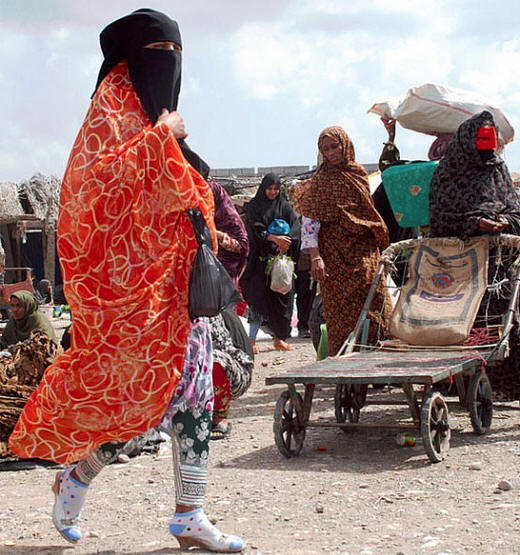
Even the clothes of the residents, especially the women reflect an exotic blend of culture both in the breath of geography and in the depth of time. At once conservative and yet provocative, stylish yet orthodox. The women also wear masks that would fit in well at an masquerade ball.
 |
| At once conservative and yet provocative. Woman walking the the Thursday market in Minab. Note the red mask on the woman at the far right. Image credit: Omid Salimi at TravelPod |
Smoking Water Pipes
 |
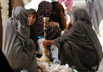
| Women sharing a waterpipe at Minab's bazaar. Image credit: Karapapa at Flickr |
The women vendors in the bazaar invariable smoke a waterpipe or hubble-bubble while awaiting customers for their wares. The waterpipe, whose use in smoking is antithetical to Zoroastrian principles, is said to have originated in India where it is called a hookah. It is also sometimes called a nargeela from the Persian word narghile, meaning coconut, or galyan perhaps from the Arabic gal, to boil - perhaps bubble - since this is what happens when smoke that is generated on the top of the waterpipe is drawn by sucking through water at the bottom of the contraption. The water cools the smoke generated by charcoal which heats tobacco placed just beneath the charcoal holder.
When a waterpipe is shared, each person may have an individual mouthpiece. While originally a past-time of the wealthy and powerful in the Mughal court of India - and therefore a status symbol - the habit appears to have gained currency in Hormozgan during the time of Shah Abbas (1571-1629), when the king wrestled control of the region from the Portuguese. For some reason the habit became especially popular with women.
 |
| Hazareh Castle (Bibi Minoo) ruins overlooking the dried Minab river bed. The capacity of the river can be gauged by the size of the bridge and the walled banks. Image credit: various and Travel Pod |
The only historical structure in present-day Minab town are the ruins of a structure called Hazareh Castle previously called the castle of Bibi Minoo (also see reference to the Bibi Maryam mausoleum in Qalhat, Oman). It is believed that Minab town was constructed by two sisters named Bibi Minoo and Bibi Nazanin. The castle sits on a height guarding the entrance to Minab and nowadays its main interest to the local people is for newly weds to complete a walk around the castle believing that the custom will ensure an enduring marriage and bring them good luck as a couple.
Minab city and its bazaar is the modern successor to Old Hormuz City that lay somewhat halfway between Minab and the shore. That city has disappeared completely, destroyed first by Turkic-Mongol raiders and then by benign neglect. Its site has been largely ploughed over and its building materials used for buildings in Minab.
Old Hormuz was a rich city and its wealth was coveted by the Mongol armies that were swarming across the traditional Aryan lands looting and destroying cities and kingdoms in their path.
|
Old Hormuz
Old Hormuz City is likely the city from which the Zoroastrian migrants sailed for the shores of India.
Location of Old Hormuz
 |
| Minab river when dry Image credit: Girl Solo |
Henry Yule, translator of Marco Polo's Travels (Chapter 19) quotes Colonel Pelly, the British Resident at Bushehr as saying, "The ruins of Old Hormuz, well known as such, stand several miles up a creek, and in the centre of the present district of Minao (Minab). They are extensive (though in large part obliterated by long cultivation over the site), and the traces of a long pier or Bandar were pointed out to Colonel Pelly. They are about 6 or 7 miles from the fort of Minao, and the Minao (Minab) river, or its stony bed, winds down towards them. The creek is quite traceable, but is silted up, and to embark goods you have to go a farsakh (farsang - 5 to 6 km) towards the sea, where there is a custom-house on that part of the creek which is still navigable. Colonel Pelly collected a few bricks from the ruins. From the mouth of the Old Hormuz creek to the New Hormuz town, or town of Turumpak (Turan Bagh) on the island of Hormuz, is a sail of about three farsakhs. It may be a trifle more, but any native tells you at once that it is three farsakhs from Hormuz Island to the creek where you land to go up to Minao. Hormuzdia was the name of the region in the days of its prosperity. Some people say that Hormuzdia was known as Jerunia, and Old Hormuz town as Jerun (in this I suspect tradition has gone astray). The town and fort of Minao lie to the N.E. of the ancient city, and are built upon the lowest spur of the Bashkurd mountains, commanding a gorge through which the Rudbar river debouches on the plain of Hormuzdia."
Colonel Pelly's description places Old Hormuz at 10 km southwest of Minab (See map above) and 15 km from the coast. In his description, since Col. Pelly appears to treat the creek where he found the traces of a long pier, the river Minab, and river called Rudbar(?), a river that runs through Minab city, as different entities. [Rudbar is the name of a river in Luristan though rubar in Persian also means a valley drained by a river with flowing water, or a land watered by many streams. Rud means river in Persian.] Abu Abd al-Idrisi (Edrisi) wrote in the 12th century, that "Hormuz is built on the banks of a creek called Heiz, derived from the Persian Gulf. Vessels reach the town by this channel."
 |
| Image accompanying report by Siamak Sarlak, archaeologist and head of excavation team in Minab. Possibly remnants of Old Hormuz City's wharf / port. The water expanse in the background is fairly large and may be at the junction of the Minab river and bay. Image credit: The Archaeology Thread at Skyscraper City |
These references almost make it sound that Old Hormuz was not situated on the river Minab but rather on an inlet (a creek or channel) from the Persian Gulf or perhaps a bay. In some way it makes sense not to have a harbour on a river that is subject to flooding. The inlet could have run beside the river Minab.
One of the earliest indications of Old Hormuz City's location (old cities were often the centre of city-states) comes to us from Classical writer Arrian (Lucius Flavius Arrianus (c 86 - 160 CE). Arrian records that Alexander's Admiral, Nearchus, landed on the shores of Hormozgan (Harmozeia), then part of Kerman (Carmania), at the mouth of the river Anamis ( see Rudbar above). The Anamis river mentioned by Arrian and other classical Western authors* has been identified with the Minab river by several authors**. Arrian also informs us that Nearchus found the country a kindly one, and very fruitful in every way except that there were no olives.
[*Anamis in Arrian's Indica 32.2, 35.7; Ananis in Pliny's Nat. Hist. 6.107; Andanis in Ptolemy 6.8.4; and Sandis in Mela, 3.75.
**Such as Forbiger at p. 551, Sykes at p. 302, and Silberman at p. 302.]
The mouth of the river Minab (also called Minao) opens onto a bay which would have provided safe-harbour and a harbour deep enough for sea-going ships.
Today, there is nary a trace of the ancient city, though the photograph we show to the left, ostensively that of an ancient wharf, appears to have a large body of water in the background - larger than the known width of the river Minab.
The location of Old Hormuz is further suggested by Istakhri, a medieval Persian geographer from the 10th century CE and author of Al-Masalik wa al-Mamalik (951) and Al-Aqalim. In his writings, Istakhri noted that Old Hormuz - or as it is sometimes called, Hormuz of the mainland - lay at a distance of two post-stages or half a day's march from the coast starting at the head of a river called Al-Jir (now the Minab River). Istakhri also says that from the ports ships had to sail one parsang, that is 5 km or 3 miles down river in order to arrive at the sea (likely meaning the bay). In addition to Istakhri's report, another 10th century writer Muhammad Abul-Qasim Ibn Hawqal in Surat al-Ard, Face of the Earth, (977) states that Hormuz was situated at the head of a bay called Jayz.
In describing Hormuz, Istakhri speaks of great warehouses in its outlying villages two leagues from Minab city. In its surrounding fields, palm-groves were plentiful. Cultivated as well were dhurrah (millet), indigo, cumin and sugar cane. The fields were irrigated by underground channels called kareez (qanat in Arabic) which brought water down from the water table in the hills.
While a great body of literature favours looking for Old Hormuz near Minab, Sir Aurel Stein in 1932-3 concluded that the most likely site for Old Hormuz was Kalatun, a village and presently a north-western suburb Bandar Abbas.
As we note in our section titled Migration from Old Hormuz to New Ormaz / Hormuz City & Island under Post Arab Invasion Historical Milestones, in the face of continual Mongol-Turkic raids, Old Hormuz City was eventually abandoned and the trading centre was moved to New Hormuz City on Hormuz Island.

