Page 1: Kerman Region

Contents
|
Suggested additional reading:

|
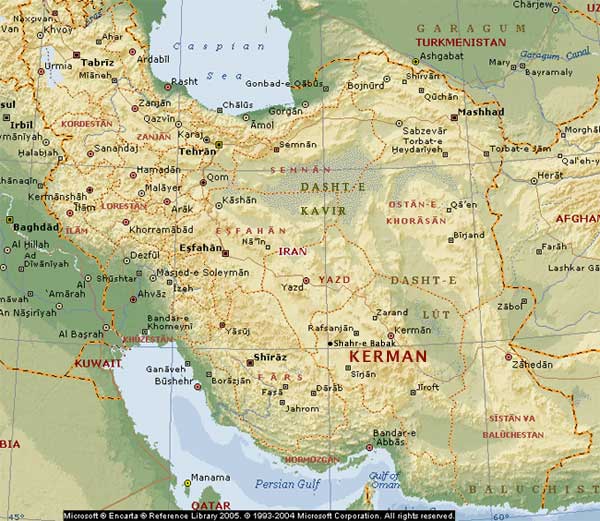
| Map of Iran. Base map credit: Microsoft Encarta |
Kerman Province
 |
Kaluts at Kavir-e Lut (Lut Desert). Ka-lut is said to be a contraction of Kavir-e Lut,
and it also appears to refer to the rock hills. Image credit: Ninara at Flickr. |
Kerman province lies towards the southeast of Iran and its capital bears the same name. The province has a population of about three million people. The Dasht-e Lut, the desert of Lut, lies to the north and northeast of the province giving rise to a desert culture such as that in Yazd. Here too, the kareez (qanat) system is used to bringing water from the mountains to the valleys and plains The west and south-western parts of the province are mountainous. Kerman city itself lies close to towards the centre of the meeting of these two natural features.
Kerman is Iran's largest producer of handmade carpets and a major exporter of pistachio nuts.
Macro Polo's Observations about Kerman
A southern arm of the Aryan trade roads ran through Kerman province and city. A branch would also have passed through the southern town of Jiroft. Marco Polo passed through the kingdom of Kerman in 1271 CE after visiting Yazd. Chapter 17 of The book of Ser Marco Polo, the Venetian, Vol. I, translated by Henry Yule, describes Kerman as follows:
"In this kingdom (of Kerman) are produced the stones called turquoises in great abundance; they are found in the mountains, where they are extracted from the rocks. There are also plenty of veins of steel and Ondanique (Yule's note: Ondanique of the Geog. Text, Andaine of Pauthier's, Andanicum of the Latin, is an expression on which no light has been thrown since Ramusio's time. The latter often asked the Persian merchants who visited Venice, and they all agreed in stating that it was a sort of steel of such surpassing value and excellence, that in the days of yore a man who possessed a mirror, or sword, of Andanic regarded it as he would some precious jewel. This seems to me excellent evidence, and to give the true clue to the meaning of Ondanique. I have retained the latter form because it points most distinctly to what I believe to be the real word, viz. Hundwaniy, 'Indian Steel'). The people are very skilful in making harness of war; their saddles, bridles, spurs, swords, bows, quivers, and arms of every kind, are very well made indeed according to the fashion of those parts. The ladies of the country and their daughters also produce exquisite needlework in the embroidery of silk stuffs in different colours, with figures of beasts and birds, trees and flowers, and a variety of other patterns. They work hangings for the use of noblemen so deftly that they are marvels to see, as well as cushions, pillows, quilts, and all sorts of things (Yule's note: It is possible that the 'hangings' spoken of by Polo may refer to the carpets. I have seen a genuine Kerman carpet in the house of my friend Sir Bartle Frere. It is of very short pile, very even and dense; the design, a combination of vases, birds, and floral tracery, closely resembling the illuminated frontispiece of some Persian manuscripts). In the mountains of Kerman are found the best falcons in the world. They are inferior in size to the Peregrine, red on the breast, under the neck, and between the thighs; their flight so swift that no bird can escape them."
Kerman's Ancient Peoples & History
Kerman has a number of historic and archaeological sites as well as a functioning 2 - 3,000 year-old village of troglodyte cave dwellers, Maymand. The archaeological sites include Konar Sandal at Jiroft, Tepe Yahya, Tell Iblis and Shahdad. The historic sites include the fortresses of Bam and Nayen described below.
Jiroft was a artefact manufacturing town on the Aryan trade routes. Some of the artefacts were made from a jade-like stone called chlorite. Some 90 kilometres (50 mi) from Jiroft, Tepe Yahya was the location of a chlorite stone mine. In the absence of the discovery of another chlorite mine closer to Jiroft, we must assume that the stone used by Jiroft's artisans came from Tepe Yahya. Carl Lamberg-Karlovsky of Harvard University excavated a site named Tepe Yahya in the 1970's. In the forested mountains 150 kilometres (90 mi) north of Jiroft, other archaeologists have discovered copper mines that appear to have produced the ore for the copper and bronze artefacts unearthed in Jiroft's gravesites.
The land of Kerman was once the Achaemenian satrapy (subject kingdom / province) of Karmana, transliterated by the Greeks and into English as Carmania. While the name is mentioned only once in a Achaemenian royal inscriptions, not in a list of subject nations, but in a descriptive inscription at Darius's palace at Susa [which noted it is said that sissu, or wood of the jag (Old Pers. yaka) tree - wood for the palace's construction - was brought in from Gandhara and Karmana], Carmania Karmana is mentioned fairly frequently in connection with travelers between there and Susa in the Persepolis fortification (records and archives) tablets.
Bam Fortress / Arg-e Bam
 |
Bam Panorama before the December 26, 2003 6.5 R earthquake.
Image credit: Wikipedia |
Before its destruction in an earthquake in 2003, the fortress at Bam was reputed to be the largest adobe (unbaked clay) building in the world. Bam is some 180 km southeast of the provincial capital of Kerman.
One claim is that the original fortress at Bam was constructed in 500 BCE, which would make it an Achaemenian era fortress, and that it continued to be used until 1850 CE. Other literature state that the structure is a Parthian era (247 BCE - 224 CE) fortress. The fortress contained a citadel or fortified palace at its highest point. The area within its 6-7 metre high and 1815 metre long walls, covers 180,000 square meters.
The fortress has two main sections. The first section includes the fortified palace (citadel) consisting of a four-seasonal residence, the administrative palace, barracks for the guards, a stable for 200 horses, a mill, and a 40 metre deep well. The rooms in the four corners of the four-seasonal residence (with an internal courtyard) were occupied in the different seasons with each section most comfortable for a particular season. The second section surrounded the citadel contained the main entrance, a bazaar, about 400 houses and public buildings such as a school and sports halls.
The smaller buildings had unidirectional badgirs, or wind-catcher towers used to create cooling drafts, while the larger buildings had four-directional towers to catch the wind from every direction.
 |
Bam fortress before the December 26, 2003 6.5 R earthquake.
Image credit: Wikipedia |
 |
Bam fortress after the December 26, 2003 6.5 R earthquake.
Image credit: Iranmap.com |
|
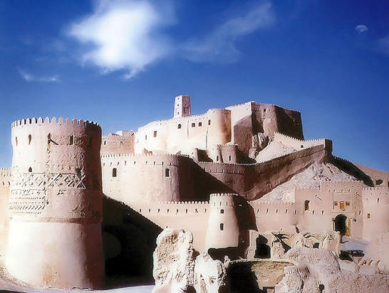
Rayen Fortress
The fortress at Rayen (see banner image) is similar in outlook and construction to the fortress at Bam, while been younger in age. It is thought to be a Sassanian era (224 CE - 649 CE) fortress. Like Bam, Rayen fortress was in use until about 150 years ago.
| View of an eastern suburb of Kerman city, the Jangal-e Ghaem (Ghaem Forest), and the Saheb Zaman mountains. Image credit: amoXi at Panoramio |
 |
» Top
Suggested additional reading:
|


