
Image credit: Hoeck at Flickr
Contents

Tajikistan Region
Page 1
Tajikistan Region & Zoroastrianism
Page 2
Sugd / Sogdiana
Page 3
Pamirs
Page 4
Pamiri Houses & Zoroastrian Symbols
Page 5
Pamiri Zoroastrian Historical Sites
Page 6
History

Sugd / Turan
Turan
Sugd-Uzbekistan Region
Sugd-Tajikistan Region
Sogdian Trade. Silk Roads
Zoroastrianism in China
Sugd / Turan Pages:
» Sugd - Uzbekistan Region
» Sugd - Tajikistan Region
» Sogdian Trade. Silk Roads. China & Zoroastrianism
Sugd / Sogdiana - Tajikistan Region
The land of ancient Sughdha (Sugd) and its Zerafshan River valley, straddles the border of Tajikistan and Uzbekistan. Sughdha is the second nation mentioned in the Avestan Vendidad (see map).
In Tajikistan, the ancient land of Sughdha form present day Sugd (Sughd) province. Sugd province includes the Yagnobi river valley as well as the Fergana / Syr Darya valley in the north.
 |
|
Map of Turan & Sugd (Tuirya & Sughdha). Click to enlarge Base map courtesy Microsoft Encarta |
Yagnob / Yaghnob

|
| Zerafshan & Yagnobi rivers in Sugd Province. Yagnobi speaking areas are shaded in red. |
|
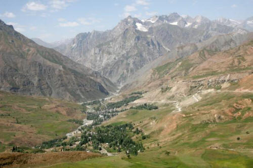
| Anzob Pass. Photo credit: Tajikistan Photo Gallery by Mikhail Romanyuk |
A hundred kilometres north of Tajikistan's capital Dushanbe, over the Anzob pass in an eastern spur of the mountains stemming from the Pamirs, lies the mysterious Yagnob (also spelt Yaghnobi) valley. Yagnob is taken to mean ice river and is a reminder of the very cold winters in the upper valley.
A tributary of the Zerafshan river, the Yagnobi river travels westward for 120 kilometres in a valley parallel to and south of the Zerafshan valley. The Yagnobi valley is formed by the Hissar range to its the south and the Zerafshan range in its north. At the end of the valley its swings northward to join the Zerafshan (also spelt Zarafshan, Zeravshan) River at Aini.
Some of the Sogdian traders who plied their trade along the Silk Roads between China and Asia Minor and even resided in China, came from the Yagnobi region of Sugd. The Yagnobi Sogdians have special links to Zoroastrianism. They left behind a legacy including Avestan texts written in Yagnobi Sogdian (see below). Even today, names like Rustam, a legendary Aryan / Iranian name, are common among the Yagnobi. The Yagnobi language spoken today is a dialect of the ancient Sogdian language which died out some time after the 10th century CE.
Nowadays, the Yagnobi people who remain as a distinct ethnic group number a few thousands. During the Soviet era, under the pretext that the Yagnobi were in danger of avalanches, the Yagnobi, in 1970, were forcibly resettled in the desolate plains of the Mirzachul region (Zafarabad) of northern Tajikistan where labour was needed to tend cotton fields. Many of the Yagnobi resisted and they were subjected to much brutality. The Soviets destroyed their villages and homes to prevent the Yagnobi from returning to their homes. Their religious books, the oldest of which was 600 years old, were destroyed and their ethnicity officially abolished. Why the Soviets went to such lengths to destroy the Yagnobi as a distinct ethnic group is a matter of speculation. The Yagnobi were resented by many Islamist Tajiks who felts that they were late in adopting Islam and continued to practice an ancient religion, probably Zoroastrianism or a variant.
(Also see From the mountains to the Lowlands - the Soviet Policy of "Inner-Tajik" Resettlement by Thomas Loy)
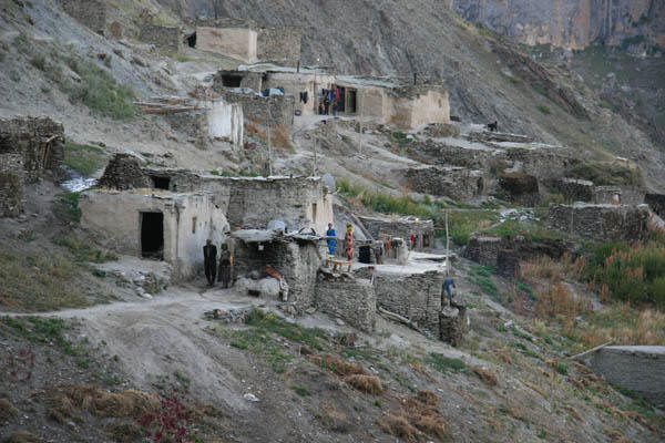
Nevertheless, in 1983 and the years following, a few surviving and brave Yagnobis started returning to their ancestral lands. They re-established small settlements and rebuilt their destroyed homes. By 1990, when the Post-Soviet Dushanbe-based Council of Ministers passed the decision to officially re-establish all Yagnobi villages whose populations had been resettled, only about 300 people were living in the Yaghnob valley. The Council asked the Tajik Academy of Science to support the preservation of the Yaghnobi language (Badenkov et al., 1994, pp. 476-84; Gunja, 1996, pp. 68-69).
|
| Yagnobi Settlement. Photo credit: Tajikistan Photo Gallery by Mikhail Romanyuk |
Addition information and images can be found at:
» Tajikistan Photo Gallery by Mikhail Romanyuk
» History of the Yagnobi People
» Yaghnob at Tourism in Tajikistan
» Yagnob.org. Includes a pdf viewing of Journey to Sogdiana's Heirs by Anvar Jamolzoda.
» Image gallery at Yagnob.org
Eternal Coal Fires

|
| Kuhi Malik coal fires |
In the Yagnob valley, in the vicinity of Kishlak Ravat, is the Kuhi Malik gorge, famous since Herodotus, for its "fiery caves."
Here in the caves are coal deposits that have been burning for 3.5 million years, and in the process a vast underground labyrinth of caverns has been created.
The ever burning underground fires are reputed to have inspired the notion of an eternal flame in Zoroastrianism.
Yagnob Winters
|
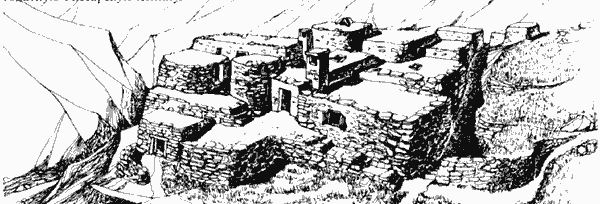
| Yagnobi houses & settlement Image credit: Silk Road Tajikistan & various locations |
The Yagnob canyon is home to the Yagnobi people. When the winter snows come, the road out of the canyon becomes impassable, forcing the inhabitants to patiently wait for the snows to melt, huddled around fires on goatskins spread on the stone floors on their homes. Monica Whitlock of BBC lived with the Yagnobi and wrote a report describing how the Yagnobi are home bound during the winter. Her report paints a picture reminiscent of the Jamshedi era account of the people waiting out a severe winter in a community housing system of connected houses and narrow alleys called a Vara. The cold winters in the canyon and the Yagnobi lifestyle makes the area a candidate (as does the Pamirs) for Airyana Vaeja during the prehistoric Jamshidi era.
Spitamen
Interestingly, in the north of Tajikistan's Sugd province, there is a town called Spitamen. It lies on the Aksuu river, and is just south of the famed Syr Darya river. The name Spitamen sounds similar to Spitama, the Avesta word used in conjunction with Zarathushtra's name (his family name?), as in Spitama Zarathushtra.
Panjikent / Bunjikath
|
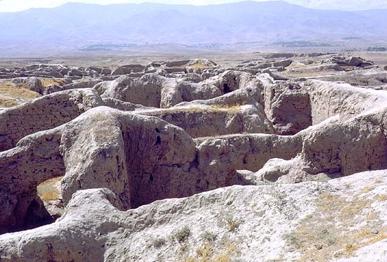
| Ruins at Bunjikath, Panjikent overlooking the Zerafshan Valley |
After the Arabs invaded Central Asia in the early eighth century CE, local Sogdian rulers of the smaller principalities in the Samarkand-Zerafshan Valley fled 60 km east to Panjikent (meaning five towns, and now in Tajikistan but previously a part of Sugd) located on the River Zerafshan and and further upstream.
Today Panjikent (also spelt Panjekent, Panjakent, or Penjikent and derived from the Sogdian Panchekanth) is one one of Tajikistan's larger cities. It is home to the poet Rudaki's mausoleum and ancient Sogdian /Zoroastrian ruins. Located on the southern slopes overlooking the city and the Zerafshan Valley - at the edge of the city of Panjikent - is the 5th century CE archaeological site of Bunjikath. In its day, the city was situated on the rim of a high terrace overlooking a fertile, well-irrigated valley.

|
| Panjikent and the Zerafshan River and valley from the Bunjikath site. Credit: Explo Guide |

|
| Site map of the ruins of Bunjikath at Panjikent. Credit: Explo Guide |
|
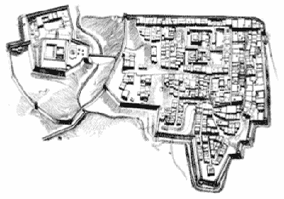
| Reconstructed aerial view and layout of ancient Panjikent Image credit: Panjakent at Tourism in Tajikistan |
Description of the site from Encyclopaedia Iranica: "Its (ancient Panjikent's) citadel (see Isakov 1979) is separated by a ravine from the shahrestan or city proper, which lies to the east of the citadel and is surrounded by fortified walls of its own. Two additional walls cross the ravine, linking the shahrestan with the citadel, and creating a unified defensive system around the entire city. The central structure of the citadel is a square fort built close to the northern part of a mountain ridge, which runs from south to north. In the end of the 7th or the early 8th century CE, a square keep was erected in the southeast corner of the fort. At the foot of the fort and to the north of it lies the lower fortification, watered by the abundant Qaynar spring. It shows traces of habitation from the 2nd century BCE. to the 1st century CE This cultural layer contains remnants of ceramics, but none of buildings. To the south of the fort stood a fortified wall, which defended the citadel against attacks from the top of the ridge. There were no buildings between the wall and the fort. On a hilly site to the east of the fort once rose the richly decorated palace of Devashtich (708?-22 CE), which apparently burned down in 722 CE. It was an expansion and an extensive reconstruction of an earlier building, dating from the 6th century CE. Another palace from the 6th century was located in the lower fortifications.
"In the 5th century the area of the city proper (without the citadel) measured about eight hectares. Straight fortified walls defended the settlement: the northern wall running along the rim of the terrace, and the eastern wall perpendicular to it. The southern wall ran straight only where the terrain permitted, and the western wall followed the irregular edge of the hill, departing from the overall regular design. The city walls of Panjikant in the 5th century were ten to eleven meters high, bristling with numerous towers, and punctured by embrasures in a chessboard pattern. Later the walls were made thicker, with fewer towers, a sloping faēade, and no embrasures close to the foundations. The residential buildings of the city consisted of several small rooms with low wooden ceilings. All walls were made of sun-dried brick and clay. The streets and alleys intersected at right angles. The land at the city center, where two temples stood, has apparently been dedicated to sacral purposes since the founding of the settlement.
"The architectural style of the temples, which by the beginning of the 8th century CE had undergone many reconstructions, can be traced back to the traditions of Bactria. The two temples are very much alike: each consisted of a central building facing east and surrounded by a yard, which was adjacent to yet another yard to the east, with an exit to the street. A visitor walking from the street towards the main building would have seen the sacred spaces of the two yards open before his eyes one after the other, until, standing in the inner yard, he would have seen not only the portico, but also the interior of the central hall, which—not enclosed by a wall—opened directly onto the portico of the main building. At the far end of the hall there was a door leading to the cella, and on each side of it two niches with clay statues of divinities. A characteristic feature of the Sogdian temple was its openness to the rays of the rising sun and to the eyes of the laity. The passageways to the corridor, which circumvented the hall and the cella behind it opened onto the portico to the sides of the central hall. A space for the sacred fire was added to Temple 1 only in the late 5th and the 6th century CE.
"The earliest nauses of the necropolis at the edge of the ancient city, with Zoroastrian ossuary burials, date back to the 5th and the beginning of the 6th centuries CE. At the end of the 5th century the area of the city had grown to 13.5 hectares. New fortifications were built to the south and east, so part of the old walls were enclosed within the perimeter of the new ones, dividing the city into inner and outer quarters. The walls of the inner city were repaired and reinforced in the 6th and the 7th centuries. They were pulled down only at the beginning of the 8th century.

|
| Reception hall of a 5-7 cent. CE Panjikent house (reconstruction by B. Marshak & E. Buklaeva; after Marshak, 2002, fig. 10). Image credit: Encyclopaedia Iranica |
"The earliest murals in the palaces of the citadel date from the 6th century. Some of the houses built during the 6th century were two stories high, with vaulted ceilings on the lower floor, and murals on the walls of some rooms. However, during the 5th-6th centuries, no building in Panjikant could rival the magnificence of the two temples, and even the houses of the most prosperous residents seemed rather humble in comparison. In the 7th-8th centuries, though, it was the houses of the rich that set the tone of urban architecture in the city. The end of the 7th century and especially the first quarter of the 8th century marked the heyday of early medieval Panjikant. At the beginning of the 8th century the spaces between the houses became passageways (covered with vaults in places), over which towered the walls of the neighbouring buildings. Not only the dwellings of the rich, but also those of the poor were more often than not two-story buildings with vaults over the rooms on the first floor. All residential houses from that period—not only those of the rich, but also of the merely well-to-do citizens—were decorated with murals and woodcarvings. Such reception halls were found in more than a third of all houses in the city. The streets were lined with small shops and artisans’ workshops, often clustered around the bigger residential buildings. The workshops of the blacksmiths and of other metalworkers are most easily identified among the ruins (Raspopova 1980). The prosperous houses often had a few shops or even a small market built on the master’s property. These commercial spaces were wide open to the street, but had no link to the living quarters of the buildings: apparently the tradesmen and small shopkeepers leased the premises from the landowners."
|
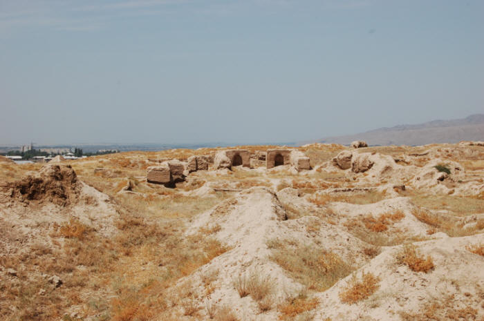
| Ruins at Bunjikath identified as Zoroastrian temples. Credit: Explo Guide |
|
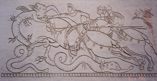
| Sketch of a relief panel in the ruins at Panjikent. Image Credit: Tirdād Gorgāni |
The murals and frescoes (some of them 15m long) portraying religious ceremonies and scenes from the famous Persian epics, and which decorated the walls of the now ruined buildings have been removed from the site and are housed in a museum in Panjikent.
In A.D. 722, Arab forces besieged and took the town. The last Sogdian ruler Devashtich together with others who had been retreating from the Samarkand region fled east to a fortress on Mt. Mug in the upper Zerafshan region. The fortress was their last refugee. However, the fortress could not stop the Arab onslaught and there the Arabs captured Devashtich and executed him after holding him prisoner for a few months. At Mt. Mug archaeologists have unearthed a treasure trove of Sogdian documents attesting to the sophistication of the Sogdian administration and legal system.
Additional Reading:
» Once more about peculiarities of the Sogdian Civilization of the 4th-10th Centuries by Boris Y. Stavisky
» Sogdian Archaeology by Boris Il'ich Marshak
» Panjakent at Tourism in Tajikistan
Sarazm
|
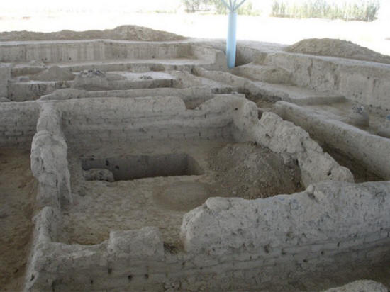
| Ruins at Sarazm. Photo: Mary Kay Magistad, PRI, at Flickr |
About 15 km. west of Panjikent (at the border with Uzbekistan), lies the site at Sarazm - the ruins of a far older, and potentially more significant, 4th -2nd millennia BCE settlement that included a palace, fire temples, administration, public and residential buildings. The site is remarkable and is testament to a thriving Bronze Age civilization.
Recovered artefacts include objects made of copper, bronze, lead, silver and gold - items manufactured locally and traded with lands as distant as Mesopotamian and the Indus Valley.
As with Panjikent, Sarazm was built on a south-bank terrace overlooking the Zerafshan valley. There the site stretches in an west-east direction. The discovery or the ruins in 1976 were initiated by a local farmer Ashurali Tailonov who after visiting a museum in Panjikent, informed local archaeologists about a bronze axe he had found not far from his home - an axe that was similar to a bronze axe he had seen during his visit to the museum. That axe had been found in the late 19th century in Yor village, Panjikent district.
|
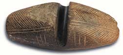
| Flattening Stone. Image credit: Sarazm at Tourism in Tajikistan |
Sarazm stands at the transition of the Zerafshan valley from flat western low lands and eastern mountainous regions, and is strategically positioned as a mining, manufacturing and export centre on the Silk roads. It was a large ancient precious metal mining center, and the Sogdians exported the extracted gold and silver east, west and south along the Aryan trade routes. In the process the residents developed one of the largest centers of metallurgy in the Central Asia.
Bronze is an alloy of copper and tin. The making of an alloy requires a knowledge of metallurgy: how to produce high temperatures, how metals synergistically work together and the proportions needed as well as how the molten alloy can be processed. The copper ore they used for the production of bronze was brought in from deposits located 40-50 km east of the site. The tin ore mines in the upper and lower Zerafshan valleys are the oldest in the ancient world that valued tin as being more precious than silver. One of the tin ore mines was at Mushiston, 40 km east of Sarazm, while another mine was in desert surrounding the lower Zerafshan at Karnab, Uzbekistan, 170 km west of Sarazm. High tin content (8-12%) bronze was expensive to produce and was a prized commodity. The high tin content bronze produced found in Mesopotamia, Oman and Harappa was likely manufactured in Sarazm since there are no other known sources and since the trade routes established by the Sogdians makes this proposition feasible. The bronze found in Oman could have been transhipped via Harappa and carried on coastal boats down the Indus to Oman at the entrance of the Persian Gulf. The bronze artefacts found in Oman as part of a collection of artefacts: pottery and beads from Harappa and bone combs and seals from Balkh. Fragments of large ore-crushing pestles and hammers, foundry forms, melting forges / smelting furnaces, casts, cast crucibles, as well as massive hammers for crushing ore have been found. (cf. The Horse, the Wheel, and Language by David W. Anthony)

|
| Beginning of 2nd millennium BCE Arrow and spears heads found at Sarazm Image credit: Bronze Age in Tajikistan |
Metal and composite items found at the Sarazm site include armour, axes, daggers, knives, lance-heads, spears, pins, fishhooks, knitting needles, razors, ornaments, jewellery and decorations.
The artisans used their stone cutting expertise to make beads and pendants from agate, onyx, obsidian, lapis lazuli, turquoise, and cornelian. The turquoise came from outcrops in the desert around the lower Zerafshan about 100 km downstream from Sarazm, and from Nishapur in north-eastern Iran. The processed turquoise was traded into Mesopotamia and the Indus valley.
Also found at the site are stamps similar to stamps found at sites in Mesopotamia, Iran, Baluchistan and the Indus valley. Other items resembling those found in the Middle East, South Turkmenistan and Afghanistan include painted ceramic kitchenware have been unearthed at the site together with six furnaces used to bake twelve forms of containers such as goblets, bowls, and jugs.
Included in the finds are the remains of a woman who was buried in clothes decorated with silver, turquoise, cornelian, lapis lazuli, and jasper beads. Gold beads adorned her hair, and on her arm she had large bracelets made from sea shells. All these items underscore the extent of the international trade in which the 4th century BCE residents were engaged and their wealth.
Only is small portion of the 100-hectare Sarazm site is accessible to archaeologists. Farmed land covers a large part of the potential extent. The site is also bounded in the north and west by the villages of Sahibnazar and Gurach, and in the north-eastern by Avazali. The exposed site includes a palace complex which covers an area of more than 250 square meters, and which consists of a large corridor, a vestibule, two halls circular altars in the center and several auxiliary structures connected by wide passages.
The etymology of the name Sarazm is unclear. Some suggestions are sar-sabz meaning the head of greenery, or sari-sabza meaning green beginning, or sari-zamin, meaning beginning of the land. These names could signify Sarazm's location between the low and high lands.
» Top
Tajikistan Pages:
» Page 1 Tajikistan Introduction)
» Page 3 (Pamirs, page 1, Introduction)
» Page 4 (Pamirs, page 2, Pamiri Houses)
» Page 5 (Pamirs, page 3, Pamiri Historical Sites)
» Page 6 (Tajikistan History)
» Site Contents